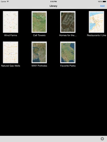
PointMarker app for iPhone and iPad
Developer: PerCon Corporation
First release : 31 Aug 2013
App size: 1.2 Mb
Log important locations or geographic data with PointMarker! PointMarker makes it easy to record points and data. Simply press and hold over any point on the map to drop a pin and then annotate the point as needed. Need to record a different data set? Just add a new map and record more points. Share map data with others by emailing both .KMZ and text files.
PointMarker allows you to:
- Record and annotate points in multiple maps.
- Press and hold to drop a pin. Press and hold on an existing pin to move it.
- Add descriptions, notes and an image to a location.
- Share data via email using either .KMZ or ASCII .CSV files.
- Move to your current location with one click or search for a location.
- Filter existing points by search Titles and Subtitles.
- Select from Standard, Satellite and Hybrid map styles.
Here are some examples of how you can use PointMarker:
- Utility companies can record locations of assets like wells, towers, sheds, etc.
- Public works and municipalities can mark project or work sites such as potholes, signage or other repair locations.
- Individuals can record their favorite locations like restaurants, hotels, beaches, parks and more.
- Educators could use PointMarker to record locations for class projects, scavenger hunts or geo-caches.
- Real Estate professionals can provide potential buyers a hotlist / hot sheet or a prospect list for buyers.
* Note: .ZIP files created for PointMarker email attachments cannot be unzipped using the OS X Archive Utility. The files can be unzipped using other utilities such as Stuffit Expander.
* PointMarker requires a Wi-Fi or cellular connection to load maps.


